

Inishturk [Mountain Common] [Inis Toirc]
Good walks are even better shared.
L6075 : Inishturk - Trig point on Mountain Common
Colin Park Photo source
Overview
Introduction
Inishturk, a charming island located just off the coast of County Galway, is not just for the adventurers; it's a haven for those seeking tranquil landscapes and stunning views. With an elevation that challenges your ability to carry just one sandwich, it promises both scenic beauty and a rewarding experience for all.
Geology
The island is predominantly composed of granite and basalt, showcasing fascinating formations that have emerged over millions of years. Glacial activity has shaped this land into its current rugged form. As you navigate the trails, you might just catch a glimpse of ancient geological secrets!
Routes
The most popular route is the Inishturk Island Loop, which spans approximately 10 km. It will take you around three hours to complete, though you might want to pause for those Instagram-worthy photos. The path offers stunning coastal views and gives you a nibble of both the island's wild beauty and its serene surroundings.
Difficulty Rating
This loop is rated as Moderate, making it accessible for most hikers—provided you remember to stretch beforehand!
Summit Features
On reaching the summit, you'll find a trig point—perfect for those who consider selfies a sport. From this vantage point, the world looks just a bit more magnificent.
Terrain
Expect a varied terrain of rocky outcrops interspersed with grassy slopes and some coastal paths. A firm pair of shoes is recommended—especially if you’re more of a Bambi on ice than a graceful gazelle!
Views
From the summit, hikers are treated to sweeping views of the Atlantic Ocean and the majestic Connemara coast. On a clear day, Clare Island emerges prominently across the waters, providing a rustic backdrop for your adventure.
Best Seasons
The best views are typically in Late Spring and Summer, but, as mentioned earlier, Autumn's hues are a sight for sore eyes. Bring your camera—it's a view you won't want to forget!
Hazards
While hiking can seem as carefree as a dandelion in the breeze, it’s essential to be aware of potential hazards. Sudden weather shifts can hit harder than your mate’s bad jokes, and the trails can become quite slippery when wet. So, wear appropriate footwear and keep an eye on that sky!
Nearby Summits
Inishturk isn’t alone in its mountainous ambitions; nearby summits like Clare Island and Croagh Patrick are well worth exploring as well. After all, why just conquer one when you can tackle a few?
Access
To reach Inishturk, you’ll need to park at the ferry terminal located in Roonagh Quay, where there’s adequate parking available. Regular buses make their way from Westport and surrounding areas, ensuring your journey won't be a long one.
Facilities
On Inishturk itself, you'll find limited facilities—it's more about the great outdoors than constant conveniences. However, after your adventure, a trip back to Westport offers a range of cafes and dining options to refuel and relive your hiking tales!
History
The name Inishturk translates as 'Island of the Wild Boar'—an interesting nod to its biodiversity and wild surroundings. The island is also steeped in local folklore, often featuring in tales that celebrate the lush culture of the region.
Inishturk beckons with the promise of breathtaking views and an escape from the hustle and bustle. Whether a seasoned hiker or a casual explorer, this island offers an enriching experience you won’t soon forget. Just remember to keep an eye on the weather, and don’t forget that sandwich!
Explore routes near Inishturk [Mountain Common] [Inis Toirc]
Walks starting near this hill. Open a route to check its map, distance and full itinerary.
Route planning notes
These notes describe possible approaches. Check a route's map and access information when planning your walk.
Inishturk Island Loop
This scenic loop traverses the island's key viewpoints, with a mix of coastal paths and hill trails.
Make a day of it, together
Find someone to share the walk with, or organise a day out along a route you like.
Photo Gallery
View all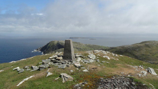 Photo could not load
L6075 : Inishturk - Trig point on Mountain Common
Colin Park
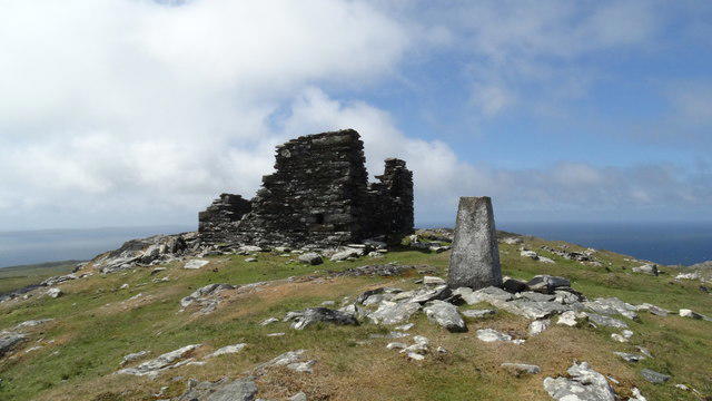 Photo could not load
L6075 : Inishturk - Trig point & remains of signal tower on Mountain Common
Colin Park
Hill facts and local notes
Classifications
Elevation
189m
621 ft
Prominence
189m
Coordinates
53.7080, -10.1122
L605751
OS Map
37
At the Summit
The summit is marked by a modest trig point, offering a sturdy vantage point for all your summit selfies.
Terrain & Geology
Inishturk features fascinating granite and basalt formations, shaped by glacial activity and erosion, providing a glimpse into the earth's ancient history.
Views & Scenery
Visitors are treated to panoramic views of the Atlantic Ocean, the rugged Connemara coastline, and the nearby Clare Island.
History & Heritage
Name Origin
Inishturk translates to 'Island of the Wild Boar' in Irish, a nod to its vibrant wildlife.
Historical Significance
The island has historical significance tied to local folklore and mythology, often referenced in stories of the region.
Getting There & Facilities
Parking
Parking is available at the ferry terminal in Roonagh Quay, with ample space for vehicles.
Public Transport
Regular bus services run to Roonagh Quay from Westport and other nearby towns.
Nearby Facilities
Limited facilities on Inishturk Island; however, cafes and toilets can be found in nearby Westport.
Safety Information
Known Hazards
- Watch out for sudden weather changes common in the region. The terrain can get slippery when wet.
General Safety Tips
- Check weather conditions before setting out
- Carry appropriate clothing and equipment
- Let someone know your planned route
- Take a map, compass, and GPS device
- Carry emergency supplies: food, water, first aid kit, torch
Hills
Some common questions about the hills answered
Are there group walks up Inishturk [Mountain Common] [Inis Toirc]?
Many walkers use Walkmates to join or organise walks with others. You can check for group walks around Inishturk [Mountain Common] [Inis Toirc] through the maps
Are there other walkers around Inishturk [Mountain Common] [Inis Toirc]?
Activity varies by location and time, but Walkmates lets you see whether others have shared walks or shown interest in this area. Find other people through the walking friends search walking friends for Inishturk [Mountain Common] [Inis Toirc] search or of course create your own walk for Inishturk [Mountain Common] [Inis Toirc]
Can I organise a walk to Inishturk [Mountain Common] [Inis Toirc]?
Yes. If there aren’t any walks listed already, you can create a walk and make it available for others to join.
If you're signed up to Walkmates, you can create a walk to Inishturk [Mountain Common] [Inis Toirc].
How do I find a walk up this hill?
There are often multiple ways to walk this hill, depending on experience and route preference. Walkmates helps you explore walks and routes that others have shared.
Can I suggest a new route up Inishturk [Mountain Common] [Inis Toirc]?
Yes. You can suggest or create routes to share with others. Walkmates focuses on the social side of walking, so routes are used to help people organise walks and explore areas together, rather than as detailed navigation tools or route libraries.
Other uses really appreciate knowledgeable walkers sharing their routes. Share your favourite route to Inishturk [Mountain Common] [Inis Toirc] here
The is an error or something incorrect about this hill. How do I let you know?
We always strive to keep the information on Walkmates as accurate as possible. If you find an error, please let us know through the contact form and we'll aim to correct it as quickly as possible
Community Discussion
Comments
Location
![Inishturk [Mountain Common] [Inis Toirc] location map](https://cdn.walkmates.com/hill-maps/hill-sources/20561/53.70799_-10.11220.png)
Grid reference: L605751
View on OpenStreetMapOpens a map in a new tab, centred on the hill.
No comments yet. Be the first.